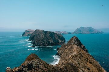
The Sonoma Coast is California’s wild edge: 17 miles of Highway 1 where wide sandy beaches sit below grassy bluffs, sea stacks rise out of the surf, and summer fog usually burns off by midday, revealing prime whale watching. This Sonoma Coast travel guide covers the run from Bodega Bay to Jenner and north to Fort Ross and Salt Point — the beaches worth stopping for, the bluff trails, the harbor seals at Goat Rock, and the Russian history on the headlands. This Sonoma Coast travel guide is built for a day trip from the Bay Area or a slow weekend at Bodega Dunes. Bring layers, check current fees and hours — and never turn your back on the ocean: this coast is beautiful, and it is not for swimming.
At a Glance: The Sonoma Coast in Brief
- Where: Sonoma County coast, Highway 1 from Bodega Head to about four miles north of Jenner
- Don’t miss: Bodega Head whale watching, Goat Rock seals, the Kortum Trail, Fort Ross
- Getting there: Highway 1 from San Francisco — Bodega Bay is about 90 minutes north. Santa Rosa, 23 miles east, makes a natural base camp — see our Santa Rosa travel guide
- Best time: Fall for warm, clear days; winter–spring for gray whales; summer fog usually lifts by midday
- Know before you go: No swimming anywhere on this coast; day-use fees apply at staffed lots; no drones in the state parks
Bodega Head: The Sonoma Coast Travel Guide Starting Point
Start at the headland guarding the entrance to Bodega Harbor. Bodega Head anchors the south end of Sonoma Coast State Park, which runs 17 miles north to Vista Trail past a dozen Highway 1 beach access points. Trails edge around the headlands for about three miles, or take the one-mile path to the Ocean Overlook — open Pacific on one side, the harbor and village on the other. Our Bodega Bay travel guide covers the town in full.
The overlook is one of California’s best land-based whale watching spots: gray whales migrate past from January through May, and the high cliffs put you right above them — bring binoculars and give it an hour. The harbor side is a popular crabbing spot along the jetty. This Sonoma Coast travel guide starts here for a reason: one short walk shows you the whole character of the coast.
Sonoma Coast Travel Guide Beaches: Goat Rock to Salmon Creek
North of Bodega Bay, the beaches come in a row, separated by rocky headlands. They look inviting and they are not for swimming, so plan on walking, beachcombing, picnicking, and watching wildlife instead — the rhythm of this Sonoma Coast travel guide.
- Goat Rock Beach: The easiest sandy beach on the coast, in a partial cove where the Russian River meets the sea, and home to a harbor seal colony — stay at least 50 yards away, especially during pupping season (March–August). Picnic tables and restrooms on site; no dogs, though leashed dogs are welcome on nearby Blind Beach. The parking lot gate sometimes closes in dangerous surf, though you can still walk in.
- Salmon Creek Beach: Nearly two miles of unbroken sand where a lagoon forms as sand closes the creek mouth — good for surf fishing and picnics. No dogs, horses, or fires: the sand protects the western snowy plover, a federally threatened shorebird.
- Shell Beach: The pick for beachcombing and tidepooling, and the Kortum Trail trailhead.
- Portuguese Beach and Schoolhouse Beach: Sandy beaches framed by rocky headlands, popular for rock and surf fishing.
- Duncan’s Landing: Spring wildflowers — and the most dangerous point on this coast, so heed the signs and stay off the rocks.
Hiking the Bluff Trails
The best way to see this coast is on foot, above it. The Kortum Trail is the classic walk in this Sonoma Coast travel guide: an easy, cliff-side trail of about four and a half miles round trip between Wright’s Beach and Blind Beach, from the Shell Beach trailhead, past wildflower meadows, sea stacks, and coves you cannot reach by car.
Shorter options work too: the Bodega Head loop takes about an hour, and the one-mile path to the overlook is the fastest whale watching vantage point. Stay on the trails — the shale is unstable and unsafe for climbing — and keep well above the highest water marks in the sand. Layers and a charged phone are part of the kit.
Jenner and the Russian River
Jenner is the small town at the mouth of the Russian River, about halfway up the state park stretch, and the natural halfway stop on this Sonoma Coast travel guide route. The river meets the sea at Goat Rock, and the estuary behind the beach is prime wildlife country — harbor seals haul out on the sandbars, osprey and herons work the calm water. The town is a handful of waterfront spots along Highway 1: stop for coffee, watch the river meet the surf, and keep driving north. Kayaks are another way to see this stretch — local outfitters run guided paddles through the estuary. Book ahead in summer.
Fort Ross and Salt Point: History and Wild Coast North of Jenner
Twelve miles north of Jenner, Highway 1 reaches Fort Ross State Historic Park. Fort Ross was a Russian-American Company settlement from 1812 to 1842 — the southernmost Russian settlement in North America — built on the ancestral homeland of the Kashia Pomo people. The stockade walls, reconstructed chapel, and Rotchev House — one of the only original buildings left from the Russian period — sit on a cliff above the sea. Entry is $10 per vehicle ($9 for seniors); check the current fee before you go. Start at the visitor center, then allow an hour for the trails and beach. No stop on this Sonoma Coast travel guide mixes scenery and history quite like it.
North of Fort Ross, the coast gets wilder. Salt Point State Park covers about 6,000 acres and more than six miles of rugged coastline, roughly 30 winding miles north of Jenner. Gerstle Cove is the centerpiece: a sheltered cove and state marine reserve where tidepools teem with life and nothing may be taken — the Gerstle Cove marine reserve has protected this water since 1971. Look for tafoni, the honeycomb weathering in the sandstone, and hike inland to the pygmy forest. Campgrounds: Gerstle Cove (30 bluff-top sites) and Woodside (79 inland). Check the current day-use fee first; this winding stretch rewards an early start.
Where to Eat and Sleep on the Sonoma Coast Travel Guide Route
Bodega Bay is the place to eat. Sonoma County Tourism’s guide to the coast points to the harborfront staples: the Tides Wharf Restaurant, the oceanfront spot from Alfred Hitchcock’s The Birds; the Boat House, known for Dungeness crab cake sandwiches and rock cod fish and chips; and Spud Point Crab Company, a tiny cafe and bait shop where the owners catch their own seafood. Order at the counter, take it to the beach.
Sleeping on the coast means camping, and this Sonoma Coast travel guide leans on the state park campgrounds. Bodega Dunes is the big one — up to 99 sites in peak season, with token-operated hot showers, flush toilets, and a water fill station — and Wright’s Beach has 27 sites right beside the sand, with no showers of its own. Both book through ReserveCalifornia, 48 hours to six months ahead, and summer weekends sell out fast — check the State Parks booking page before your trip. Just south of the harbor, Doran Regional Park has more than 120 tent, trailer, and RV campsites, a two-mile beach calmer than the open coast, and leashed dogs welcome. North of Jenner, Fort Ross’s Reef Campground has 20 first-come, first-served tent sites at $40 a night; check in at the kiosk 10 a.m. to 4 p.m. For a roof instead of a tent, Bodega Bay’s inns and lodges are the practical pick.
Practical Info: Fees, Dogs, and Safety
A few logistics round out this Sonoma Coast travel guide.
- Fees: Expect a $10-per-vehicle day-use fee at staffed lots (Bodega Dunes, Fort Ross); Highway 1 pullouts are free but fill early. Confirm current rates before you go.
- Dogs: Leashed dogs are welcome at Doran Regional Park and Blind Beach, but banned on Salmon Creek, Goat Rock, and Bodega Dunes beaches to protect snowy plovers; none in the Willow Creek or Pomo Canyon campgrounds.
- Camping reservations: Book Bodega Dunes and Wright’s Beach through ReserveCalifornia (1-800-444-7275), 48 hours to six months ahead. Inside 48 hours, remaining sites sell first-come, first-served at the kiosk from noon.
- Safety: This coast is not for swimming — strong rip currents, heavy surf, and sudden swells make even shallow water dangerous. Keep children back from the highest water line, never turn your back to the ocean, and stay off wet rocks and unstable bluffs.
- Weather: Fog, wind, sun, or rain can all show up in one day — dress in layers and keep a charged phone handy.
- Drones: Not allowed in the Sonoma-Mendocino Coast District state parks.
FAQ
Can you swim on the Sonoma Coast?
No. Strong rip currents, heavy surf, and sudden swells make the water dangerous at every beach on this stretch. Hike, beachcomb, and picnic instead, and keep kids back from the waterline.
When is the best time to visit the Sonoma Coast?
Fall is the sweet spot: warm, clear days, fewer crowds. Winter through spring is whale season, with gray whales passing from January through May. Summer is cooler and foggier, though the fog usually burns off by midday.
Is the Sonoma Coast travel guide route dog-friendly?
Partly. Leashed dogs are welcome at Doran Regional Park and Blind Beach, the go-to stops with a dog. But the state park beaches on this Sonoma Coast travel guide route — Salmon Creek, Goat Rock, and Bodega Dunes — prohibit dogs to protect snowy plovers and harbor seals.
Do I need reservations to camp on the Sonoma Coast?
For Bodega Dunes and Wright’s Beach, yes — book through ReserveCalifornia up to six months ahead; summer weekends sell out. Fort Ross’s Reef Campground is first-come, first-served, so arrive early.
Conclusion
The Sonoma Coast rewards the slow driver: bluff trails and seal colonies, a Russian fort on a cliff, tidepools at Gerstle Cove, and a harbor where the crab boats still come in. Use this Sonoma Coast travel guide to pick two or three stops instead of seeing all 17 miles in a day: Bodega Head, Goat Rock, Fort Ross. Then keep going north — our Mendocino village guide picks up from here.