Crescent City is the largest city on the Redwoods Coast, a town of about 6,000 in Del Norte County in the far northwest corner of California, just south of the Oregon border. This Crescent City travel guide treats it as what it is: the primary gateway to Redwood National and State Parks, the only UNESCO World Heritage Site in California, which draws more than 1.5 million visitors a year. The city is named for the crescent-shaped sandy beach that fronts it, and it carries a second name earned the hard way: “Comeback Town, USA,” after a 21-foot tsunami in March 1964 flooded 29 city blocks and the town rebuilt.
That history gives Crescent City a different feel from the smaller redwood towns to the south. It is a working harbor town and the main lodging base for the northern redwoods, with old-growth groves, a tide-dependent lighthouse, and wild beaches all within a short drive. Plan on two days: one for the redwoods east of town, one for the lighthouse, harbor, and coast. This Crescent City travel guide covers the redwoods, the lighthouse, and the coast in the order that makes sense on the ground.
At a Glance
- Why come: the gateway to the northern redwoods, a low-tide lighthouse, and a wild, uncrowded coast — the pitch for this Crescent City travel guide in one line
- Best for: travelers using this Crescent City travel guide to plan a redwoods basecamp trip
- Top stops: Jedediah Smith Redwoods State Park, Battery Point Lighthouse, Del Norte Coast Redwoods State Park, Crescent City Harbor, Tolowa Dunes State Park
- Day trips: Oregon Caves National Monument about 1.5 hours away; Crater Lake National Park about 3.5 hours away; Brookings, Oregon, 26 miles north
- Best time: May through mid-October for the driest weather and full services
- Where to stay: motels and inns along US 101 in town, plus campgrounds at Jedediah Smith and Mill Creek
Jedediah Smith Redwoods State Park
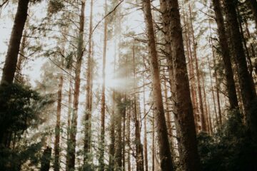
Nine miles east of Crescent City on Highway 199, Jedediah Smith Redwoods State Park protects 10,000 acres of old-growth coast redwood, bisected by the Smith River, California’s last major free-flowing river. Established in 1929, it is the most cathedral-like of the redwood parks, and it is the first stop in this Crescent City travel guide for a reason: the groves here are the ones people picture when they think of the redwoods.
Start with Stout Memorial Grove, the first walk this Crescent City travel guide recommends: a 0.5-mile easy loop through towering old growth on the Smith River. The Grove of Titans, reached via the Mill Creek Trail, holds some of the largest known coast redwoods. The Boy Scout Tree Trail runs 5.5 miles, and Simpson-Reed Grove is another easy old-growth walk. Howland Hill Road, a scenic gravel drive through the park about five miles east of town, is the access point for Stout Grove and the Grove of Titans, but it is not recommended for trailers or RVs.
Day use runs sunrise to sunset, and a state park day-use fee of $8 per vehicle applies at the day-use area. There is no entrance fee at Redwood National Park itself. Dogs are not allowed on trails, except service animals. The campground is open year-round. Check hours, fees, and current conditions on the official Jedediah Smith Redwoods State Park page, and go deeper with the Jedediah Smith Redwoods guide.
Battery Point Lighthouse
Battery Point Lighthouse, built in 1856 and first lit on December 10 of that year, is still an active private aid to navigation, with resident keepers. Museum tours include the keeper’s quarters, furnished with artifacts from the 1850s, and a climb into the light tower. The lighthouse withstood the 1964 tsunami with the keepers stranded inside.
The lighthouse is the most tide-dependent stop in this Crescent City travel guide. The catch, and the thing that makes it memorable, is the access: the lighthouse is reachable on foot only at low tide, across a roughly 200-foot rocky crossing from the foot of Lighthouse Way. Waves can cover the crossing, and sneaker waves are a hazard, so this is a stop you plan around the tide, not around your schedule. Check NOAA tide predictions for Crescent City and the official page before going, and never cross when waves cover the causeway. Tours are tide-permitting, and hours vary by season, so check current hours and admission before you go. The full history and visiting details are on the Del Norte County Historical Society Battery Point Lighthouse page.
Del Norte Coast Redwoods State Park
Just south of Crescent City, Del Norte Coast Redwoods State Park covers 33,000 acres and eight miles of wild coastline where tall trees meet the sea. It is the rugged half of this Crescent City travel guide, and the place to go when you want the redwoods without the crowds.
The signature hike in this Crescent City travel guide is the Damnation Creek Trail: two steep miles, four miles round trip, with roughly 1,000 to 1,100 feet of elevation, from redwoods down to rocky tidepools. Note that the trail’s bridge near the coast has been dismantled, so coastal access at the end is limited. The California Coastal Trail runs the length of the park. Mill Creek Campground is the basecamp here — and the camp pick in this Crescent City travel guide — with reservations from May through September and first-come, first-served sites the rest of the year. Summer temperatures run 40 to 80 degrees, winter 30 to 55, and you should dress for rain from November through May — the area gets up to 100 inches of rain a year. Wilson Beach, also called False Klamath Cove, is good for tidepooling at low tide but not safe for swimming. Campgrounds are $35 a night. See trail details and rules on the official Del Norte Coast Redwoods State Park page.
Harbor, Beaches, and Ocean World
Crescent City Harbor is a working harbor with charter fishing and seasonal Dungeness crabbing, seafood occasionally sold straight from the boats, and harbor restaurants including the Chart Room and Fisherman’s Restaurant. Come hungry: the harbor restaurants are the best dinner bet in this Crescent City travel guide. The B Street Pier is an easy public fishing spot. Just offshore, Castle Rock National Wildlife Refuge holds more than 100,000 seabirds plus harbor seals, elephant seals, and sea lions; you can sea-kayak about a half-mile from the harbor to see them.
The Visit Del Norte County Crescent City guide covers beaches, the harbor, redwoods, history, and family fun in one place. The beaches within city limits are Crescent Beach, South Beach, Pebble Beach, and Enderts Beach. The walk from the Crescent Beach Overlook to Enderts Beach is about three-quarters of a mile, and Enderts Beach is a noted low-tide tidepool spot. South Beach is good for stand-up paddleboarding and beachcombing, and Pebble Beach Drive is the scenic shoreline drive, with sea stacks and coves. Kellogg Beach, north at Tolowa Dunes, is known for agates.
Ocean World, a privately owned aquarium at 304 Highway 101 South in the harbor area, is the family stop in this Crescent City travel guide, with fully guided 45-minute tours with a touch-and-feel tide pool, a 500,000-gallon aquarium, a shark-petting tank, and a seal and sea-lion presentation. It has operated since 1964 and makes a good one-to-two-hour family stop. Check current hours and pricing before you go, as published hours vary. Tolowa Dunes State Park, just north of town, adds beaches, dunes, wetlands, Lake Earl — the largest lake in Del Norte County — horseback riding, and the Kellogg Loop Trail. A second lighthouse, St. George Reef Lighthouse, is visible from trails off North Pebble Beach Drive but is not open to the public on foot.
Getting There: Planning Your Crescent City Travel Guide Trip
Crescent City is about 325 miles from San Francisco, roughly a six-hour drive north on US 101 — the drive this Crescent City travel guide assumes you are making. From Eureka, it is about 80 miles north on US 101. From Brookings, Oregon, it is 26 miles south, and from Grants Pass, Oregon, about 70 miles southwest on US 199 to Hiouchi, then about nine miles to town. The nearest visitor centers are the Crescent City Information Center at 1111 Second Street and the Hiouchi Visitor Center on Highway 199, nine miles east of town. Del Norte County Airport, also called Jack McNamara Field, has daily direct flights to Oakland on Contour Airlines. Driving distances and visitor-center details are on the NPS Redwood directions page.
As the largest town between Eureka and Brookings, Oregon, Crescent City is the main lodging base for the northern redwoods, with motels and inns concentrated along US 101 in town, plus vacation rentals. Camping options are the Jedediah Smith Campground, open year-round with reservations recommended in summer, and Mill Creek Campground in Del Norte Coast Redwoods, with reservations from May through September. For the next redwood park south on the same trip, see the Prairie Creek Redwoods guide, and for the nearest city south, the Eureka guide.
Practical Tips for Your Crescent City Travel Guide
- Best time: Parks are open year-round. This Crescent City travel guide puts the best weather from May through mid-October: driest, warmest, longest days, with summer highs typically in the 60s and morning fog common. September and October bring fewer crowds and lush greenery, with rain becoming more likely. Winter, November through March, is wet, with possible trail and road closures, but also solitude and storm watching. Campground reservations are recommended in summer.
- Fees: No entrance fee at Redwood National Park. A state park day-use fee of $8 per vehicle applies at the Jedediah Smith day-use area, payable on site, cash only. Campgrounds are $35 a night.
- Dogs: Not permitted on park trails, except service animals. Leashed pets, on a leash of six feet or less, are allowed in developed campgrounds, on beaches including Crescent Beach, Gold Bluffs Beach, and Freshwater Beach, in picnic areas and parking lots, and on the gravel road walks Cal Barrel Road in Prairie Creek and Walker Road in Jedediah Smith. Crescent City’s public beaches are dog-friendly, and there is an off-leash fenced dog park, called Dog Town, on Front Street.
- Navigation: The National Park Service warns that many GPS and mapping services give incorrect directions inside the parks. Use a printed park map and follow official road signs. Do not feed wildlife, and store food in animal-proof lockers.
FAQ
How do you get to Battery Point Lighthouse? On foot only at low tide — the most important planning detail in this Crescent City travel guide — across a roughly 200-foot rocky crossing from the foot of Lighthouse Way. Check NOAA tide predictions for Crescent City and the official Del Norte County Historical Society page before going. Tours are tide-permitting and hours vary by season. Never cross when waves cover the causeway.
Is there an entrance fee for the redwood parks near Crescent City? No entrance fee for Redwood National Park itself. A state park day-use fee of $8 per vehicle applies at the Jedediah Smith day-use area, and campgrounds are $35 a night.
Can I bring my dog? Not on park trails, with service animals excepted. Leashed dogs are welcome in campgrounds, on beaches including Crescent Beach, in picnic areas and parking lots, and on the gravel road walks Cal Barrel Road and Walker Road. Crescent City’s public beaches are dog-friendly.
How far is Crescent City from Eureka and the Oregon border? About 80 miles north of Eureka on US 101, and about 26 miles south of Brookings, Oregon. San Francisco is about 325 miles, or roughly six hours, south.
When is the best time to visit Crescent City? May through mid-October for the driest weather and full services. Summer brings foggy mornings and peak crowds. Winter is wet, so dress for rain from November through May, but it is quiet, with dramatic coastal storms.
Crescent City is not the prettiest town on the Redwoods Coast, and it does not try to be. It is the useful one: the place with the beds, the harbor, and the roads into the biggest old-growth groves in California. Use this Crescent City travel guide as a basecamp plan, and let the redwoods and the tides set the schedule.